Three millennia in one valley
The Alcantara Valley is one of those places in Sicily where historical stratification is not a metaphor: it is a material fact. From the river mouth to the upper valley, the same spaces have been Greek, Roman, Byzantine, Arab, Norman, Hohenstaufen, Aragonese and finally Italian. Each domination left concrete signs, a bridge, a castle, a cube-plan church, a place name, that today coexist in the villages and along the river.
This page is a synthesis guide to the history of the valley. For individual villages and fortresses, see the dedicated pages.
Prehistory and protohistory
Traces of human presence date back at least to the Neolithic, around 6000 BC, with inhabited caves documented in the territory of Castiglione di Sicilia. The valley, fertile and rich in water, was a natural corridor between the slopes of Mount Etna and the coast.
In the protohistoric age, the first hilltop settlements developed: some defensive fortresses (for example what would become Castel Leone in Castiglione) have protohistoric foundations.
The Greeks and Naxos (734 BC)
In 734 BC, according to tradition, settlers from Chalcis in Euboea founded the colony of Naxos at the mouth of the Alcantara, the first Greek foundation in Sicily. The choice of Capo Schisò (near present-day Giardini-Naxos) is explained by the presence of a natural harbour and the possibility of reaching the interior along the river valley.
Naxos became the bridgehead for the hellenisation of eastern Sicily and itself founded other colonies (Leontinoi, Catania). The river, cited by Thucydides in the 5th century BC as Akesines, was one of the poles of the geographical identity of Greek Sicily.
Romans and late antiquity
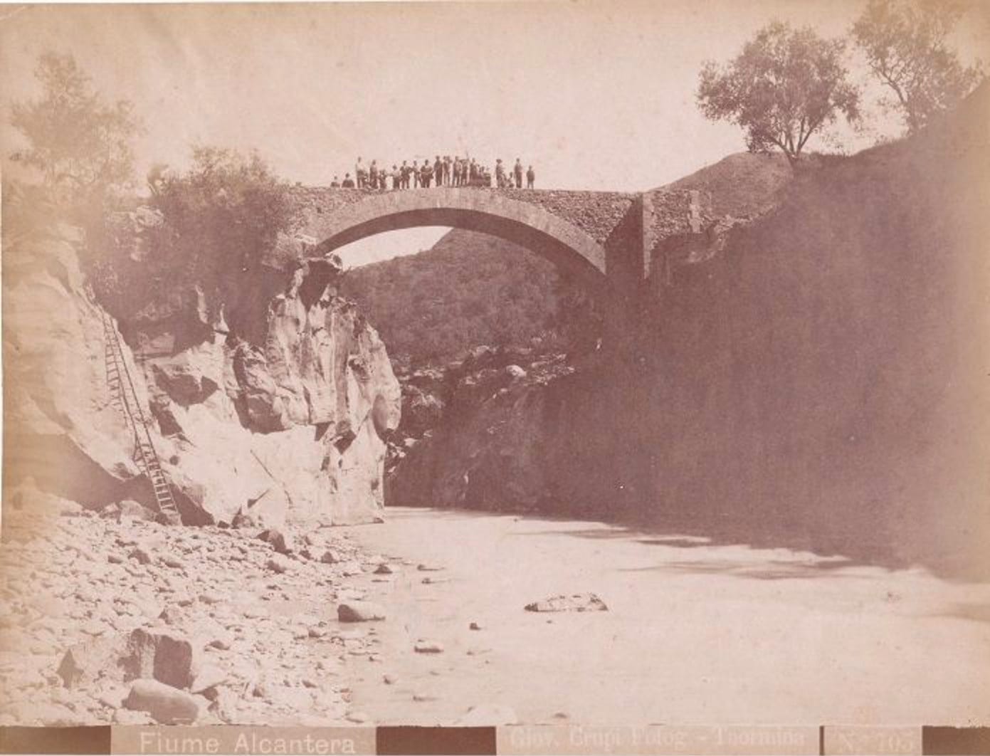
Under the Romans the valley was a romanised agricultural area, with rustic villas and road infrastructure. The multi-arched bridge at the river mouth, which would later give the river its Arabic name, was probably built in Roman times.
In late antiquity the valley was christianised. To this phase belongs the first layer of the Byzantine cubes.
Byzantines and Basilian monasticism (5th-8th c.)
Between the 5th and 8th centuries, during the Byzantine phase, Sicily entered the orbit of Eastern monasticism. The Basilian communities (monks following the rule of St Basil) settled in remote places and founded small central-plan churches: the cubes.
The Byzantine Cuba of Santa Domenica, near Castiglione di Sicilia, is one of the best preserved in Sicily. Square plan, internal dome, construction in local lava stone. It is a small jewel that tells of a little-seen but important phase of Sicilian history.
Arabs: the bridge and the name (9th-11th c.)
In the 9th century Sicily passed under Arab rule. The conquest was gradual and uneven, but it brought profound transformations:
- new crops (citrus, mulberry, rice, sugar cane);
- advanced irrigation systems;
- a new organisation of the territory;
- and, above all for our purposes, the name of the river: al-Qanṭara, the bridge, in reference to the surviving Roman bridge near the mouth.
The Arabic toponym fused with the landscape and survived all subsequent dominations.
Normans: castles and villages (11th-12th c.)
In 1061 the Normans began the conquest of Sicily. For the valley it was a decisive period:
- construction of castles or refounding on pre-existing structures (Calatabiano, Castiglione, Francavilla, Randazzo);
- birth or consolidation of the medieval villages we recognise today;
- administrative reorganisation of the territory;
- coexistence of Latin Christians, Greeks, Jews and Muslims throughout the 12th century.
This is the period in which the system of valley castles took shape, still legible in the landscape today.
Hohenstaufens and Aragonese (13th-15th c.)
Under Frederick II Hohenstaufen (13th century), Castiglione di Sicilia became a royal city with the right to mint coinage, a rare privilege that testifies to its importance. Randazzo was a stop on the itinerant court.
With the Aragonese, from 1282 onward, the castles were further fortified and adapted to new techniques of war. The valley remained a strategic corridor between coast and interior, but was also a productive agricultural area.
Modern age: agriculture and the “discovery” of the Gorges (16th-19th c.)
For most of the modern age the valley lived primarily on agriculture: vineyards, olive groves, citrus groves, hazelnut groves. The villages grew and stabilised in the forms we can still admire today. The great Sicilian nobility owned scattered fiefs in the valley.
The Alcantara Gorges were “rediscovered” as a natural phenomenon and an object of scientific study in the 18th century. Naturalists, geologists and then the first elite tourists began to reach them.
In 1693 the great earthquake that devastated eastern Sicily also struck part of the valley. Some villages (especially in the lower valley) were heavily affected. The 1818 quake also left traces.
Contemporary age (20th-21st c.)
The 20th century saw minimal industrialisation in the valley and emigration, common to many inland areas of Sicily. The railways (the Circumetnea in particular) connected Randazzo to Catania and changed mobility.
In the 1970s and 1980s a progressive environmental focus emerged:
- geological studies on the gorges;
- bird population surveys;
- early forms of protection.
Alcantara River Park (2001)
In 2001 a regional law established the Alcantara River Park, replacing the previous reserve. The park protects the river basin on the northern flank of Etna and is structured into:
- an administrative seat in Francavilla di Sicilia;
- a research, training and environmental education centre in Castiglione di Sicilia;
- a network of trails, geosites and integrated promotion projects.
The park is also a hub for sustainable tourism and valley activities: from river trekking to cycle tourism, from environmental education to food and wine tourism (Etna DOC).
The history you see
Walking in the valley today, you will recognise this stratification in concrete details:
- the bridge at Capo Schisò recalling the origin of the name;
- Roman paving in some stretches of the old paths;
- the Byzantine Cuba di Santa Domenica;
- the castles of Calatabiano, Castiglione, Francavilla, Motta and Randazzo;
- the medieval villages in lava stone;
- the Etna DOC vineyards, heirs to centuries of agriculture;
- the trails of the River Park that stitch everything together.
Further reading
- Castles of the Alcantara Valley, the fortified system.
- Valley villages, dedicated page for each village.
- Geology of the Gorges, the parallel “geological” history.