Alcantara Gorges: access, opening times, water and self-guided visits
Complete guide to the Alcantara Gorges: what they are, how to visit, public versus private access, cold water, self-guided visits and the key map nodes.
Read guideA Sicilian valley carved by lava and a river, with medieval villages built in black stone, basalt gorges and Etna DOC vineyards. Maps, GPX hikes, practical guides and village profiles, independent, regularly updated.
Answer three questions and we'll build your day in the valley, tailored to you.
Dedicated pages for the searches people make most often: gorges, Gurne, access points, cold water and self-guided visits.
Complete guide to the Alcantara Gorges: what they are, how to visit, public versus private access, cold water, self-guided visits and the key map nodes.
Read guideAlcantara Gorges opening hours and prices: the €2 municipal ticket (2026), private park access, the April–October season and seasonal time slots to verify.
Read guideThe hikes of the Alcantara Valley: the four in the gorges plus the 8 official River Park trails, from the Mojo cinder cone to Montagna Grande. Difficulty and season.
Read guideVisiting the Alcantara Gorges with children: which age is really suitable, which family trails are safe (Le Rive, Gurne), what to bring, what to avoid. Cold water 10-15°C, precautions and alternatives.
Read guideComplete guide to the Gurne dell'Alcantara at Francavilla di Sicilia in the Alcantara Valley: what the basalt pools are, an easy 1.5 km loop, viewpoints, parking, when to go and what to combine.
Read guideItinerary through the castles of the Alcantara Valley: the Castle of Calatabiano at the river mouth, Castel Leone at Castiglione di Sicilia, fortresses of Francavilla, Motta Camastra and Randazzo. History, accessibility and tips.
Read guideFully accessible riverside walk at Graniti with smooth surfaces, tactile sections, rest areas and viewing platforms over the Alcantara River.
Flat riverside walk from San Nicola bridge to the Little Gorges, with a recommended detour to the Byzantine 'Cuba' chapel.
Easy loop above the lava pools with scenic overlooks. Starts in Francavilla di Sicilia and returns through village lanes.
From San Nicola bridge to the Byzantine 'Cuba' and the medieval lava-stone town of Castiglione di Sicilia.
Riverside route along the famous lava gorges (multiple access points including Motta Camastra's municipal staircase).
Ascent to the Mojo cinder cone with a rim loop and interpretation panels. Views over Etna and Alcantara vineyards.
Panoramic ridge hike on the Peloritani: wide views over the valley and the Ionian Sea. Fair weather recommended.
Sentiero Italia CAI stage: strenuous climb from the Alcantara Valley floor at Mojo into the high pastures of the Peloritani at Contrada Rindena. Terraces, oak forest, panoramic ridges.
Sentiero Italia CAI stage: long descent from Etna North (Piano Provenzana, 1,800 m) to the Alcantara Valley floor at Mojo. A complete traverse of Etna's vegetation belts.
The Alcantara Valley is the natural hinge between Etna, the Nebrodi and the Peloritani. The river rises in the Nebrodi, near Floresta (Sicily's highest town, 1,275 m), and after about 52 km reaches the Ionian Sea at Capo Schisò, where, two and a half millennia ago, settlers from Chalcis founded Naxos, the first Greek colony in Sicily.
The name Alcantara comes from the Arabic al-Qanṭara, "the bridge", referring to a Roman bridge that once stood near the river's mouth. The landscape blends lava gorges carved by the river, citrus and hazelnut groves, Etna DOC vineyards on the volcano's northern slope, and medieval villages built in black lava stone.
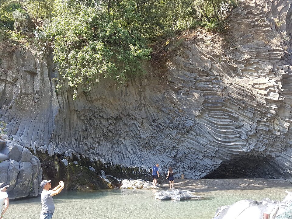
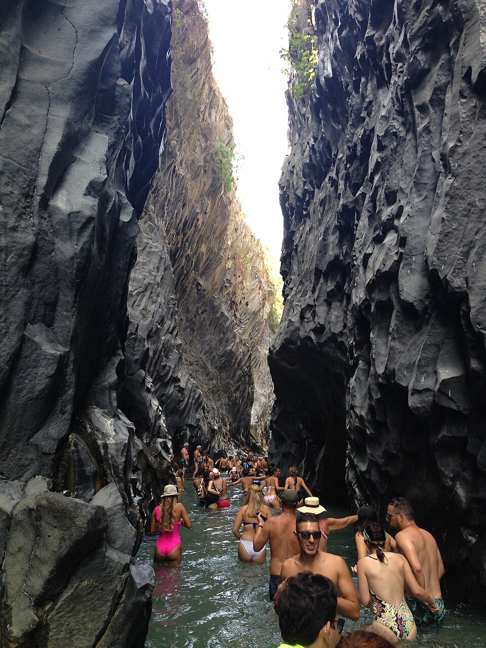
The Alcantara Gorges (also called Larderia Gorges) are one of Europe's most spectacular examples of columnar basalt. They formed about 8,000 years ago when an Etna lava flow met the cold waters of the Alcantara River.
The rapid cooling of lava in contact with water created geometric fractures forming organ pipes, fans and rosettes - pentagonal and hexagonal prismatic formations up to 20-30 meters high.
The main public access is at Motta Camastra via the municipal staircase; there are also private entrances with facilities (Botanical and Geological Park).
Medieval village on a lava spur with the Castle of Lauria and the Byzantine Cuba. Key terroir for Etna DOC wines from the north slope.
Heart of the mid-valley and starting point for the Gurne trail. The Capuchin Convent dominates the panoramic view.
Main gateway to the Alcantara Gorges with the famous municipal staircase descending into the canyon.
Lava-stone town between Etna and Nebrodi with intact medieval architecture, three mother churches and the Circumetnea Railway.
Eccentric pyroclastic cone of Etna with an educational trail and panoramic views over the valley and vineyards.
River village with the accessible "Le Rive dell'Alcantara" path and artist murals in the historic center.
Small farming village in the lower valley, known for its citrus groves and panoramic position toward Taormina.
At the mouth of the Alcantara, with a perched Norman castle and the San Marco beach.
Small mountain village on the Nebrodi slopes, surrounded by hazelnut orchards and oak woods.
The valley's highest village (758 m) with the Menhir, a natural sandstone monolith over 10 meters tall.
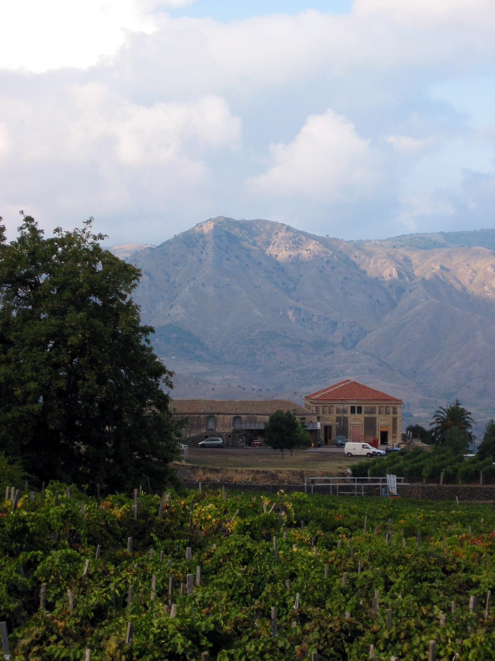
The Alcantara Valley is the heart of the Etna DOC denomination. Indigenous grape varieties - Nerello Mascalese and Nerello Cappuccio for reds, Carricante and Catarratto for whites - grow on volcanic soils between 400 and 1,000 meters.
Local specialties include Nebrodi hazelnuts, Bronte pistachios, valley citrus fruits, mountain cheeses (provola, tuma), high-altitude honeys and the famous Sicilian granita with brioche.
Book tastings and winery visits between Castiglione, Randazzo and Linguaglossa.
Riparian vegetation includes oriental plane trees, willows, poplars and oleanders. The lava walls host ferns, mosses and the rare Woodwardia radicans. On the slopes, Mediterranean maquis dominates with holm oaks, strawberry trees and broom.
Wildlife includes the white-throated dipper, kingfisher, macrostigma trout (endemic species), freshwater crab (Potamon fluviatile), green frog and several bat species in the lava caves.
Founding of Naxos at the mouth of the Alcantara, the first Greek colony in Sicily. Chalcidian settlers chose Capo Schisò for its natural harbor.
The name al-Qanṭara ("the bridge") recalls Arab rule. Introduction of citrus fruits, mulberries and irrigation systems in the valley.
Construction of castles and fortifications. Castiglione, Francavilla and Randazzo become strategic fortified towns.
The "discovery" of the Gorges in the 18th century. Development of agriculture (vineyards, citrus groves) and first scientific explorations.
Establishment of the Alcantara River Park for environmental protection and tourism development of the area.
From Taormina/Giardini-Naxos: 20 min by car on the SS185. From Catania: A18 motorway exit Giardini-Naxos, then SS185. Interbus from Catania and Taormina. Circumetnea Railway to Randazzo.
Spring (April-June) and autumn (September-October) for mild weather and ideal water levels. Summer for water activities (cold water: 10-15°C). Winter: check openings and weather conditions.
Hiking boots with grip soles for trails. For the gorges: water shoes or sandals with grip, wetsuit or thermal layer recommended. Use authorized guides for body rafting and canyoning.
The Alcantara's water is cold year-round: 10-15°C even in midsummer. Springs originate at altitude in the Nebrodi. Wetsuit recommended for prolonged stays.